
Telecommunications
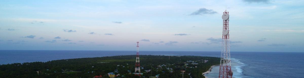
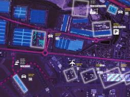
Analyzing and optimizing the existing network or planning your new 5G network requires understanding the three-dimensional spatial environment that your service will operate-in. i.e., what objects exist that may affect the signals and, ultimately, where you choose to site antenna.
Why do we need to plan our radio networks? Indeed, we can deploy as many antennae as we see fit to cover a specific area and provide the required capacity? A significant factor to be considered is cost, and good planning will at least consider three elements, capacity, coverage, and cost of deployment. Determining the 'sweet spot' will be based on the specific use case(s) that are to be addressed. For example, if there is a location where large crowds gather frequently, and access is limited for emergency services, you might consider ensuring there are more coverage and capacity made available than would typically be required. i.e., building in redundancy but at a cost.
Capacity may be a significant factor in ensuring reliable communications. In other situations, broad coverage with limited capacity may be better for lower footfall areas, such as city centers' periphery. Budgetary constraints will always come into play, and with the relatively high cost of the radio equipment, it may be both capacity and coverage need to be compromised. Therefore, planning your' use case' must consider all three components to determine an optimum solution.
As the world is a dynamic environment, care needs to be taken to monitor change and, where necessary, remodel as these changes occur or as the use cases develop further. The key to conducting the planning is knowing the area you wish to deploy and the type of connectivity demand you are trying to fulfill. Below are a few areas cloudeo supports its customers
Network Planning- Establish a correlation between network capital requirements and market revenue potential by service area for Demand Forecast.
- Monitor growth and expand capacity to reduce the risk of held orders or denial of service for Capacity Analysis.
- Planning Capital Efficiency and network expansion with fewer field visits.
- Determine market potential and identify high-revenue areas for Revenue Forecasting.
- Boost Business Intelligence with data on customers and competitors.
- Track customer connections, mix activity, and market trends within a particular service area for Campaign Management.
Engineering & Construction
- Integrating local information to produce more detailed and optimized designs with fewer delays.
- Meet service commitment dates by tracking expansion & construction progress for Network Activation.
- Contractor Management by providing contractors accurate designs and monitor construction progress.
- Gaining service area insights and support crew safety for field operations staff.
Sales & Service Delivery
- Identifying areas of opportunity, monitoring network expansion, and determining accurate installation for new customers.
- Saving the cost of site visits with office access to data such as drop requirements and network capacity.
- Create an accurate model of true revenue potential for future expansions.
- Identify new high-value service areas and improve marketing campaign efficiency.
Customer Care
- Enabling service technicians to generate repeated trouble reports.
- Reducing mix up by mapping & evaluating disconnects for targeted retention programs.
- Allowing dispatchers to process customer service requests and follow through.
- The Retail Store Locator allows customers and staff to learn more about services and navigate to the closest retail store.
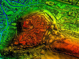 Intermap Technologies High-resolution terrain models give planners a reliable and accurate (one-meter resolution) planning tool to ensure the best possible assessment of a projec... | 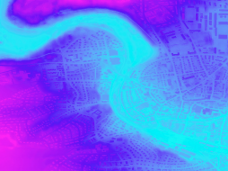 Intermap Technologies High-resolution terrain models give planners a reliable and accurate (one-meter resolution) planning tool to ensure the best possible assessment of a project... | 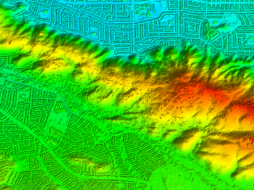 Intermap Technologies NEXTMap One™ offers the most recent and up-to-date digital elevation models, with one-meter resolution, for every state in the US (excl. A... |
 Airbus Defense and Space OneAtlas Analytics leverages premium Airbus satellite imagery, AI, and cloud computing technologies to extract actionable insight fast, in a cost-effective w... |  Airbus Defense and Space OneAtlas Data is a unique place for quick and easy access to updated High resolution satellite imagery and layers at your fingertips. Based on the Airbus con... |  Planet Power your applications and analytics with seamless Planet Basemaps built from the most recent imagery over broad areas. With daily, global imaging, Planet s... |
 Planet Frequent, global imagery is a powerful source of truth. But harnessing that data can be challenging, even for the most seasoned users, and manual, time-inten... | 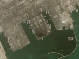 Planet Frequent, global imagery is a powerful source of truth. But harnessing that data can be challenging, even for the most seasoned users, and manual, time-inten... |  Planet Access and download past imagery from the PlanetScope Archive catalogue over any area of interest. PlanetScope satellites capture daily imagery going back to... |
 Planet Stay ahead in today’s rapidly evolving business landscape with a persistent view of business operations and assets – everywhere on Earth. But traditional ima... |  Planet Select 10,000km² of PlanetScope satellite imagery al a carte. Perfect for projects with strict scopes and deadlines, customers can pre-pay for imagery, past... | 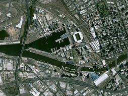 Airbus Defense and Space Pleiades is an optical satellite constellation providing very high-resolution products (50cm) with a 20-km swath. Both the space and the ground segment have... |
 Sparkle Have you always wanted to use AWS but didn't want to run over budget? Then Prepaid AWS Cloud is for you. Prevent cost overruns by pre-purchasing just the amo... |  Planet Access the rich archive of imagery from the longest running satellite in the Planet catalogue, RapidEye. Perfect for a “high level” overview, the 5-meter res... |  Planet With an industry-leading combination of coverage and cadence, Planet delivers Earth imaging data at unprecedented scale. Planet’s 15 SkySat satellites gather... |
 Planet Get a snapshot of your area of interest to discover patterns, detect early signals of change, and make timely, informed decisions. With 15 SkySat satellites... |  Airbus Defense and Space The SPOT imagery products offer high resolution over broad areas using the SPOT satellites. An acquisition covers large areas in a single pass at resolutions... |  Airbus Defense and Space TerraSAR-X reliably provides high-resolution SAR imagery with a resolution of up to 0.25m independent of weather conditions and illumination. The products al... |
 21AT TripleSat Constellation Archive has the right tools when you need a time-series of images to map or monitor your area of interest. You can r... |  21AT TripleSat Constellation Tasking has the right tools when you need a time-series of images to map or monitor your area of interest. With a st... |  Hochschule für Wirtschaft und Umwelt Nürtingen-Geislingen Visibility Analysis shows if radio masts, wind turbines, transmission lines, and other similar infrastructure installations are visible from... |