
Marine
Marine ecosystems are subject to many direct human-caused pressures. Some have global implications, like warming water, which changes ocean currents and global climate; some are regional, like ocean acidification, overfishing, and invasive species; some are local, like pollution and beach erosion. These stressors, which are even more prevalent in the ocean, can have cumulative effects on marine ecosystems, which are the basis for what we now call the Blue Economic (which ranges from fishery and recreational uses to extraction. Their impact is expected to be even stronger in enclosed and semi-enclosed basins like the Mediterranean or the Gulf of Mexico, to name just two, where high population density and the impact of large-scale tourism flow compound the effect of other commercial maritime activities. Improved knowledge of the consequences of this confluence of stressors on marine biodiversity and ecosystem functioning is vital to our survival as a society and species.
Although the oceans make up 70 percent of the Earth's surface and 99 Percent of its ecosystems and home to 91 percent of all species, in-situ measurements and observations could so far only explore less than five percent of the world's oceans. Remote-sensing Earth Observation with high-resolution satellite imagery is irreplaceable for ocean monitoring and the Blue Economy that relies on it, providing insights into ecosystems and marine life for the fishing industry, measuring temperatures (essential for weather forecasting, for example), or monitoring shipping lanes and locating vessels. And very high-resolution satellite data can be combined with sparse in-situ observations (e.g., autonomous observation platforms—buoys, moorings, ships-of-opportunity) to create computational models; ultimately, this can provide an unprecedented capability to observe, understand, and anticipate marine events that impact maritime safety, security, and sustainability.
Remote sensing technologies present a wide variety of advantages, including a higher taxonomic resolution and the capability to provide rapidly – often in near real-time – information regarding broad geographic areas or large temporal scales. Technological advancement is evolving in two main directions: (i) innovative molecular approaches for rapid biodiversity assessment; and (ii) (optical) sensor systems, which allow us to operate and collect data over broad spatial and temporal scales. Methods able to combine both sets of affordances are thus highly desirable.
Thanks to EO Systems like Sentinel, there have been various improvements to applications such as:
- Mapping of fishing zones
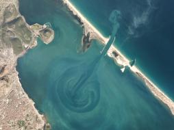
- Forecasting algal blooms
- Better forecasting of new areas accessible due to ice melting
- Water depth, winds, waves, and current monitoring for renewable energies and ship routing
- Forecasts of regional sea-level rise and storm surges
- Monitoring and prevention of coastal erosion
- Supporting environmental regulations and Marine Protected Areas (MPAs).
Optical, thermal, and radar images from airborne and satellite sensors offer many new opportunities for the direct monitoring of biodiversity, for observing patterns in the land and sea which relate directly to biodiversity, or for the provision of environmental data layers that are needed to build predictive models of species and habitat distributions. Take the Sentinel system, for example,
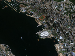
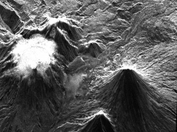
Sentinel 1 is a C-band synthetic aperture radar (SAR) satellite with cloud-penetrating ability, delivering images in various modes and swaths related to marine and maritime needs, sea-ice extent oil-spill monitoring, and ship detection for maritime security. The way that radar waves bounce off objects helps determine intertidal and salt-marsh habitats' size and composition. 10-meter resolution optical images from Sentinel-2 of the coastal zone, as with Sentinel-1, will significantly enhance our ability to detect changes in intertidal and shallow subtidal habitats. Meanwhile, Sentinel-3 is designed for wide-field ocean color viewing, altimetry, and sea surface temperature. Sentinel-3 will continue the progress made by other ocean-viewing satellites such as SeaWiFS, MERIS, and MODIS. The use of remote sensing represents a cost-effective tool that complements conventional in situ samplings. The in-situ measurements are typically based on discrete data sets with limited spatial and temporal coverage, limiting the phytoplankton dynamics' analysis concerning human activities.
Cloudeo provides access to scientifically qualified and regularly updated digital data to help scientists protect the marine environment and biodiversity. One example is Polar Environment Monitoring, which allows researchers to assess environmental impacts on the Arctic and Antarctic and to conduct environmental, climate remotely, and oceanographic research: Monitoring water quality, temperature, currents, salinity, sea ice, sea level, or wind; insights into biogeochemistry are essential for human well-being, sustainable aquaculture, oil and gas exploration, deep-sea mining, and marine renewable energy sectors.
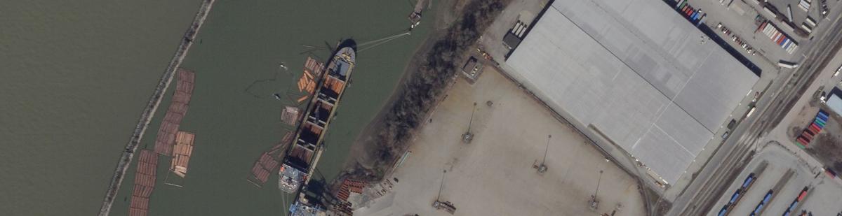
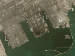
Using satellite data, cloudeo customers can develop high-resolution coastal models to manage and monitor coastal areas to manage better aquaculture farms and the sustainable exploitation of the ocean's living resources. EO data are essential to creating safer and more ecologically aware marine navigational maps, monitoring marine habitat and benthic ecosystems, at-risk coastal properties, or infrastructure assessment. They improve safety at sea and pollution response by providing oceanic parameters for pollutant drift forecasting like oil spills, vessel identification, illegal fishing detection, AIS data validation, coastal erosion detection, and algal blooms identification. Synthetic-aperture Radar (SAR) satellite data can locate ships in large-scale ocean areas; VHR optical satellite data help determine details such as vessel type and accurate measurements.
Copernicus Marine Service strives to provide critical indicators monitoring the changing environmental conditions in the context of climate change. Key variables help track the vital health signs of the ocean and changes in line with climate change: Knowing how much heat is stored in the sea, the ocean's pH, how fast the sea levels are rising, and sea ice is melting is essential to understanding the current state and changes in the sea and climate. This information is critical for assessing and confronting oceanic and atmospheric changes associated with global warming. These data can be used by scientists, decision-makers, environmental agencies, and the general public to measure our environmental directives' responses.
The ocean monitoring value chain covers many domains related to coastal and marine exploitation and preservation, like aquaculture, fisheries, water quality, and maritime transport. While this is still mainly the domain of users in the public sector, the increased importance of the Blue Economy has led to a significant increase in users from the private sector.
 cloudeo You have a plan and budget right now, which needs geo resources like data, software, or cloud resources within the next year, but you do not know exactly?... | 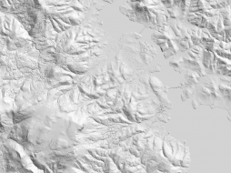 Airbus Defense and Space Elevation4 provides highly accurate up to 3m vertical accuracy at 4m grid spacing elevation information anywhere in the world, independent of relief and weat... | 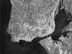 SI Imaging Services KOMPSAT-5 Archive HR offers synthetic aperture radar (SAR) imagery in high-resolution mode with 0.85-meter resolution and a swath width of 5... |
 SI Imaging Services Synthetic Aperture Radar (SAR) imagery in standard mode at 2.5-meter resolution and a swath width of 30 km offered by KOMPSAT-5 Archive ST.... |  SI Imaging Services KOMPSAT-5 Archive WS offers synthetic aperture radar (SAR) imagery in wide-swath mode with 20-meter resolution and a swath width of 100 km.... |  SI Imaging Services KOMPSAT-5 Tasking offers the latest synthetic aperture radar (SAR) imagery with up to 0.85-meter resolution in 3 different acquisition modes... |
 HySpeed Computing LandMask is a geoservice that explicitly masks land and other non-aquatic components, such as vegetation, snow and ice, from water in each s... |  Airbus Defense and Space OneAtlas Analytics leverages premium Airbus satellite imagery, AI, and cloud computing technologies to extract actionable insight fast, in a cost-effective w... | 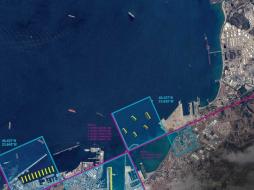 Airbus Defense and Space OneAtlas Data is a unique place for quick and easy access to updated High resolution satellite imagery and layers at your fingertips. Based on the Airbus con... |
 Racurs Simplify frequently used workflows with a rich library of professional synthetic aperture radar (SAR) processing tools with PHOTOMOD Radar c... | 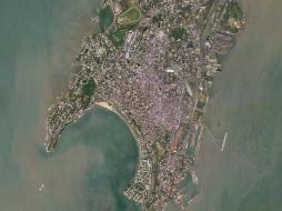 Planet Power your applications and analytics with seamless Planet Basemaps built from the most recent imagery over broad areas. With daily, global imaging, Planet s... | 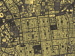 Planet Frequent, global imagery is a powerful source of truth. But harnessing that data can be challenging, even for the most seasoned users, and manual, time-inten... |
 Planet Frequent, global imagery is a powerful source of truth. But harnessing that data can be challenging, even for the most seasoned users, and manual, time-inten... | 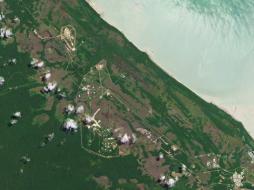 Planet Access and download past imagery from the PlanetScope Archive catalogue over any area of interest. PlanetScope satellites capture daily imagery going back to... | 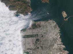 Planet Stay ahead in today’s rapidly evolving business landscape with a persistent view of business operations and assets – everywhere on Earth. But traditional ima... |
 Planet Select 10,000km² of PlanetScope satellite imagery al a carte. Perfect for projects with strict scopes and deadlines, customers can pre-pay for imagery, past... |  Airbus Defense and Space Pleiades is an optical satellite constellation providing very high-resolution products (50cm) with a 20-km swath. Both the space and the ground segment have... |  Sparkle Have you always wanted to use AWS but didn't want to run over budget? Then Prepaid AWS Cloud is for you. Prevent cost overruns by pre-purchasing just the amo... |
 Planet Access the rich archive of imagery from the longest running satellite in the Planet catalogue, RapidEye. Perfect for a “high level” overview, the 5-meter res... |  Planet With an industry-leading combination of coverage and cadence, Planet delivers Earth imaging data at unprecedented scale. Planet’s 15 SkySat satellites gather... |  Planet Get a snapshot of your area of interest to discover patterns, detect early signals of change, and make timely, informed decisions. With 15 SkySat satellites... |